


repérage rando de la vigne en rose

adye
User

Length
10.7 km

Max alt
494 m

Uphill gradient
269 m
Km-Effort
14.3 km

Min alt
322 m

Downhill gradient
270 m
Boucle
Yes
Creation date :
2021-05-09 07:09:04.936
Updated on :
2021-05-13 15:50:01.008
2h55
Difficulty : Difficult

FREE GPS app for hiking
 SityTrail
IGN / Geographical institutes
SityTrail Plus
The world is yours!
About
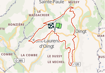
Trail Walking of 10.7 km to be discovered at Auvergne-Rhône-Alpes, Rhône, Val d'Oingt. This trail is proposed by adye.
Positioning
Country:
France
Region :
Auvergne-Rhône-Alpes
Department/Province :
Rhône
Municipality :
Val d'Oingt
Location:
Saint-Laurent-d'Oingt
Start:(Dec)
Start:(UTM)
621476 ; 5089488 (31T) N.
Comments